
WHAT IS HEAT?
HEAT is an acronym for the HELCOM Eutrophication Assessment Tool developed for assessessment of eutrophication status in the Helsinki Convention area, i.e. the Baltic Sea.
The Helsinki Commission, or HELCOM, works to protect the marine environment of the Baltic Sea from all sources of pollution through intergovernmental co-operation between Denmark, Estonia, the European Community, Finland, Germany, Latvia, Lithuania, Poland, Russia and Sweden. HELCOM is the governing body of the “Convention on the Protection of the Marine Environment of the Baltic Sea Area” (i.e. the Helsinki Convention).
HELCOM’s vision for the future is a healthy Baltic Sea environment with diverse biological components functioning in balance, resulting in a good ecological status and supporting a wide range of sustainable economic and social activities. For three decades HELCOM has been working to protect the marine environment of the Baltic Sea. This work has been driven by the specific environmental, economic and social situation in the Baltic region and the specific sensitivity of the Baltic Sea.
The work of HELCOM has led to improvements in various fields such as pollution (eutrophication and hazardous substances) and protection of species and habitats, but further work is still needed. More information is available via http://www.helcom.fi.
HOW HAVE HEAT TOOLS BEEN DEVELOPED?
HEAT is a flexible, multi-metric and indicator-based tool for assessment and classification of ’eutrophication status’.
The first HEAT version (HEAT 1.0) was originally developed for HELCOM’s thematic assessment of eutrophication in the Baltic Sea region 2001-2006 and comply with EU Water Framework Directive assessment principles.
A slightly updated and improved version (HEAT 2.0) matching the requirements of the EU Marine Strategy Framework Directive has been developed by the HARMONY project and used for assessment of eutrophication status in the eastern parts of the North Sea.
A version complying with the EU Marine Strategy Framework Dirctive as well as making use of the full range of HELCOMs Baltic Sea-specific target values (HEAT 3.0) was developed and used for an updated concise assessment of eutrophciation status in the Baltic Sea region 2007-2011.
HOW IS HEAT BEING USED?
HEAT has as indicated above been used for various thematic assessment and scientific studies of eutrophication in the Baltic Sea region, not only for snapshot (2001-2006 and 2007-2011) but also for studies of long-term trends in eutrophication status.
HELCOM EUTRO-PRO and HOLAS (2001-2006)
The HELCOM integrated thematic assessment of eutrophication in the Baltic Sea (2001-2006) is a result of over three years of work by tens of experts from all the coastal countries around the Baltic Sea. For the first time such an assessment compiles and synthesizes all available information concerning the eutrophication status of the Baltic Sea and provides a classification of the eutrophication status (based on HEAT) of almost 200 areas around the Baltic Sea. According to the assessment, most of the areas in the Baltic Sea were classified as having a moderate, poor or bad eutrophication status (see Figure 1 below). Only 13 of them – located in the Gulf of Bothnia and in the Kattegat – were classified as being “not affected by eutrophication”.
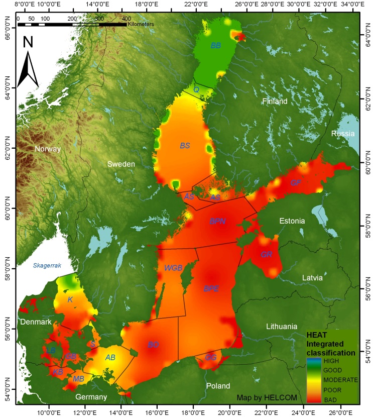
Figure 1: Map of Baltic Sea eutrophication status 2001-2006. From Andersen et al. (2011). Map produced by Samuli Korpinen (SYKE). Please click to enlarge.
HELCOM’s concise assessment of eutrophication status (2007-2011)
An updated assessment of eutrophication status of the open parts of the Baltic Sea covering the period 2007-2011 was published in 2013. The assessment, being based on HEAT 2.0, revealed the the eutrophication problem areas was expending, now including also the Bothnia Bay.
Long-term temporal and spatial trends (1901-2012)
NIVA Denmark Water Research has together with collaborators from Aarhus University (Denmark), Stockholm University (Sweden), Helsinki University (Finland), the Marine Research Centre at the Finnish Environment Institute as well as HELCOM carried out and published an analysis on long-term temporal (1901-2012) and spatial trends in eutrophication status of the Baltic Sea.
This comprehensive study reveals when eutrophication started to occur in different parts of the Baltic Sea, when eutrophication peaked, when recovery began as well as how reductions of nutrient inputs have reversed the trends and led to significant large-scale improvements in eutrophication status. A time-lapse presentation of these trends covering 112 years can be seen in Fig. 2.
Figure 2: Time lapse of the temporal development of eutrophication status for all basins in the Baltic Sea. The panel in the upper right corner is 5-year running mean integration all basins into an integrated Baltic Sea-wide assessment. Based on Andersen et al. (2015). Map produced by Ciaran Murray (BIOS/AU) and Jesper Andersen (NIVA Denmark).
The study clearly documents that reduction of both inputs of nitrogen and phosphorus is a cure that works as prescribed cf. Figure 3. Although significant progress have been attained, additional reductions will be needed before the Baltic Sea can be classified as unaffected by eutrophication.
WHERE CAN I READ MORE?
The following reports are based on applications of HEAT:
- HELCOM (2009): Eutrophication in the Baltic Sea. An integrated thematic assessment of the effects of nutrient enrichment in the Baltic Sea region. Baltic Sea Environment Proceedings No. 115.
- HELCOM (2010): Ecosystem Health of the Baltic Sea. Baltic Sea Environment Proceedings No. 122.
- HELCOM (2013): Eutrophication status of the Baltic Sea 2007-2011. A concise thematic assessment. Baltic Sea Environment Proceedings No. 143.
- EEA (2019): Nutrient enrichment and eutrophication in Europe’s seas. Moving towards a healthy marine environment. EEA Report No. 14/2019.
Articles describing various HEAT versions as well as results from several assessments of eutrophication status in the Baltic Sea and North Sea:
- Andersen et al. (2011): Getting the measure of eutrophication in the Baltic Sea: towards improved assessment principles and methods. Biogechemistry 106: 137-156.
- Andersen et al. (2010): A simple method for confidence rating of eutrophication status assessments. Marine Pollution Bulletin 60:919-924.
- Andersen et al. (2014): Nitrogen inputs from agriculture: Toward better assessments of eutrophication status in marine waters. AMBIO 43(7):906-913.
- Fleming-Lehtinen et al. (2015) Recent developments in assessment methodology reveal an expanding eutrophication problem area in the Baltic Sea. Ecological Indicators 48:380-388.
- Andersen et al. (2017): A Baltic Sea-wide analysis of temporal and spatial trends in eutrophication status. Biological Reviews, DOI: 10.1111/brv.12221.
- Murray et al. (2019): Past, Present and Future Eutrophication Status of the Baltic Sea. Frontiers in Marine Science 6(2): 265-276.
- Ramon et al. (2025): Temporal and spatial trends in eutrophication status in the Oslofjord, Norway. Science of The Total Environment, DOI: https://doi.org/10.1016/j.scitotenv.2025.179462.
In case you have any queries in regard to HEAT (or other assessment tools, e.g. BEAT, CHASE or HOLAS), please do not hestitate to contact NIVA Denmark.

